Rare Amber Weather Warning Issued by the Met Office: Heavy Rain and Flooding Expected
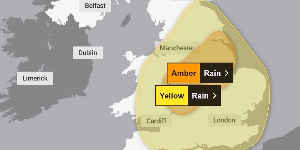
In a significant weather development, the Met Office has issued a rare amber weather warning for heavy rain, predicting that substantial rainfall could lead to widespread flooding across parts of the UK. This warning, which was announced around 10 am on Sunday, is set to impact a large area of the Midlands, extending its reach into Yorkshire & Humber, as well as London and the southeast of England. The amber warning will be in effect from 5 am to 9 pm on Monday, September 23.
Understanding the Amber Weather Warning
The amber weather warning signifies a heightened risk of severe weather conditions, indicating that heavy rain is expected to produce flooding and travel disruptions. The Met Office has cautioned that an area of intense rainfall is anticipated to develop across central and southern England during the early hours of Monday. This rain is expected to move north and west, becoming slow-moving in certain areas for several hours before weakening and moving eastward later in the evening.
Rainfall Projections
According to the Met Office, not all regions within the amber warning area will experience the same level of rainfall. However, some areas could see between 60 to 80 mm of rain, with a few locations potentially receiving 100 to 120 mm or more. This substantial accumulation of rain is likely to result in travel disruptions and localized flooding. The Met Office has also warned that lightning could pose an additional hazard in certain areas.
Travel Disruptions and Safety Precautions
The Met Office has emphasized the potential for “dangerous road conditions” due to the heavy rain. For those who must travel during this period, it is crucial to remain vigilant and drive cautiously. The advice is clear: if you encounter floodwater, it is not safe to drive, walk, or swim through it. Residents are urged to avoid floodwaters whenever possible, and in the event of fast-flowing or deep water, they should call 999 and wait for assistance.
The Broader Weather Context
The amber warning overlaps with a separate yellow weather warning that was issued by the Met Office the previous day. This yellow alert covers a much larger area, including the east Midlands, east of England, London, southeast England, northwest England, southwest England, Wales, west Midlands, and Yorkshire & Humber. The yellow warning is set to last for 24 hours, from midnight Sunday to midnight Monday.
The yellow warning indicates that areas of heavy rain are expected to affect many parts of England and Wales throughout Monday. While there is some uncertainty regarding which specific areas will experience the heaviest rainfall, the Met Office has identified parts of the Midlands, northeast England, and east Wales as the most likely to see significant accumulations. Rainfall amounts of 30 to 50 mm could occur in various locations, with some areas potentially receiving 80 to 100 mm over the course of 12 to 24 hours.
Conclusion
As the UK braces for this rare amber weather warning, it is essential for residents and travelers to stay informed and prepared for the potential impacts of heavy rain and flooding. The Met Office’s warnings serve as a crucial reminder of the power of nature and the importance of taking precautions during severe weather events. By staying vigilant and following safety guidelines, individuals can help mitigate the risks associated with this impending weather system.
